 Date: 2013-02-05 13:06:59
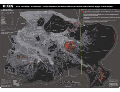
| |  Water Area Changes in Southeastern Louisiana After Hurricanes Katrina and Rita Detected with Landsat Thematic Mapper Satellite Imagery Water Area Changes Fall 2004 to Mid-October 2005 Fastlands: Agricultural and develope Water Area Changes in Southeastern Louisiana After Hurricanes Katrina and Rita Detected with Landsat Thematic Mapper Satellite Imagery Water Area Changes Fall 2004 to Mid-October 2005 Fastlands: Agricultural and develope
Add to Reading ListSource URL: www.lacoast.govDownload Document from Source Website File Size: 3,64 MBShare Document on Facebook
|